|
The main river divides in two shortly after entering the Parish (right), the northernmost channel was a Mill Race, called Mill Brook. They meet again near Gawbridhe shortly before joining the Parrett. Within the village there are numerous ditches and culverts flowing into, and joining, both channels. Both rivers are relatively free of phosphate upstream of the village (with some seasonal variations) but become more polluted as agricultural rhynes join them downstream of the village.
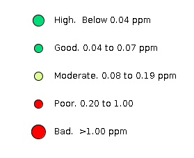
The stream behind the Car Park at the Cartgate roundabout is poor quaity (W17, 0.20ppm). It drains a area of agricultural land much of which has no adjacent margin. Part of this flow drains into Cartgate Pond where the phosphate is quickly removed by a rich mix of aquatic and riperian plants.
Bower Hinton Brook (W27-32) flows from the hills south of he village, in a northerly direction to join the main river in the village centre. It is a deep rhyne with, under normal conditions, little more than a trickle of water. Occasionally, however, it rapidly fills (and indeed overflows) after a sudden storm. The load on this stream depends inversely on the porosity of the hillside soil which ranges considerably through the agricultural cycle as it depends on the crop root depth. The high level of phosphate in W27-32 (0.35 tto 1.28ppm) is caused by such an event shortly after seed planting but before germination when the land was most susceptible to run-off which overwhelmed the structures put in place to arrest it. Such events are short-lived, seldom lasting more than a day.
This is the main river through the system. It passes close to Martock Sewage Treatment Works and a large chicken farm (between W3 and W2). It is worth reporting that neither of these were noted as a significant source of phosphate. The main outflow from the Sewage Works has been moved to the Parrett downstream from Gawbridge and the outflow into Hinton Meads Brook now is either unused or only used in an emergency.
Mill Brook is the old Madey Mill Race. It takes a largely consistent volume of water from the main river allowing excess to enter Hurst Brook and, if necessary, flood the adjacent road and Recreation Ground. Mill Brook flows though the village centre picking up water from two rhynes (Furbers Rhyne and Cobdens Rhyne) downstream. These bring agricultural leach water often from fields with very small margins making Mill Brook quite badly polluted depending on the season. In general we see a greater concentration of phosphate in this watercourse than in the parallel Hurst Brook and this seems to be due mainly to the two rhynes which both drain agricultural areas.
|