The results of the survey are grouped geographically below into the three areas which are shown on the map. For detailed data of the three surveys, follow the links on the right
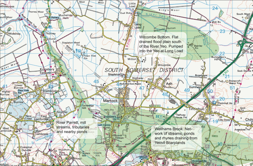
The Parrett forms the western boundary of the Parish and samples have been taken throughout its length, from some tributaries as they enter the river on both banks, as well as from some adjacent ponds. The Parrett is a heavily polluted river peaking in summer mainly because the volume of water decreases. It serves to transport phosphate rather than a source of it. Under the winter drainage protocols this phosphate normally flows straight through to the Bristol Channel. Under the summer drainage protocols much of this nutrient rich water is diverted articicially onto the Levels.
Three sewage tretment plants drain into this stretch of the Parrett, South Petherton, Martock and Kingsbury Episcopi. None of these removes phosphate and they are a major source of the Parrett phosphate, possibly over 25%.
Wellhams Brook is the name used by the Environment Agency to describe the system of tributaries that drain the western fringe of the Yeovil Scarpland east of Martock all of which converge to join the Parrett just upstream of Gawbridge. The main tributary is known locally as Hurst Brook (or Hinton Meads Brook) which divides shortly after entering the Parish creating a mill stream which once powered Madey Mill in Martock. The Mill stream (Mill Brook) rejoins Hurst Brook shortly before the confluence with the Parrett. The whole area contains a network or rhynes and ponds and is subject to frequent flooding. Phosphate levels are variable and linked to agriculture. No sewage treatment plants drain ino this system.
This scheme, developed by local and FWAG expertise, is an effective mechanism for controlling flooding of the village. It operates in various places in the Wellhams Brook catchment and has resulted in the creation of numbet of ponds of varying sizes throughout he catchment. Evidence is merging that these can also play a significant part in removing nurients suchas phosphorus from the water through he growth of healthy oxgenating plans in and around the ponds. The ponds are also emerging as very significant centres of biodivesity.
Witcombe Bottom is an area to the north in the parish of Ash. It is the floodplain of the River Yeo. It is now drained by a network of rhynes flowing into Witcombe Bottom Main Drain which is regulated by the pumping station on the River Yeo at Long Load. It has always been an area of dairly farming which is now dominated by a large dairy (in excess of 1000 cows) which has, in turn, in the last few years, has increaisingly dominated the agricultural rotations and farming practices in both Parishes.
There is a barrier across the Yeo at Long Load, adjacent to the pumping station, which is normaly raised in summer and lowered below the water in winter. This allows upstream farmers to access irrigation water in summer when the level is maintained high. Water is regularly pumped up from Witcombe Main Drain into the Yeo in winter and when necessary in summer. Whitcombe Main Drain is a major contributor to the phosphate pollution of the Yeo.
One small sewage treatment works, Tintinhull, feeds the drain network. It does not have a phosphate removal stage yet. The measurements suggest that the impact of this plant is very small compared with that of agriculture of the area.
The River Yeo joins the Parrett downstream of both Parishes and some initial sampling has been done in Langport downstream of this confluence. |